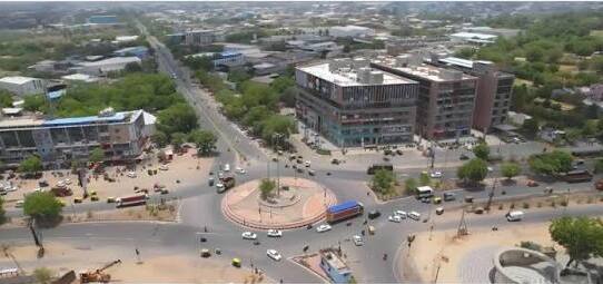
Ramaswamy Circle — one of Mysuru’s most historically important, most institutionally rich, and most transit-active roundabouts — stands at the heart of the Chamarajapuram / KG Koppal zone on Rani Jhansi Lakshmi Bai Road (JLB Road), at the convergence of the city’s most significant civic and educational arteries. The circle functions as a critical node in Mysuru’s daily transit ecosystem — positioned within the city’s iconic palace and university belt, flanked by the University of Mysore campus, the RTO Circle (123 metres north), Maharaja College and its hostel complex, and Mysuru City Railway Station just 331 metres away — making it one of the most rail-proximate and institutionally clustered roundabouts in all of Karnataka’s royal capital. The KSRTC City Circular Service route — which connects the City Bus Stand, Sub-Urban Bus Stand, and City Railway Station in both clockwise and anti-clockwise directions — specifically includes Ramaswamy Circle as a designated waypoint, confirming its place at the geographic and operational heart of Mysuru’s city transit network. KSRTC bus services from Ramaswamy Circle connect northward via RTO Circle toward Kuvempunagar, Bogadi, Vidyaranyapuram, and JP Nagar, and southward toward Chamarajapuram, the Sub-Urban Bus Stand, and beyond. The first KSRTC bus (Route 2R) departs at 5:01 AM and the last (Route 13) runs until 10:49 PM.

Ramaswamy Circle Location
- Address: Ramaswamy Circle, Rani Jhansi Lakshmi Bai Road (JLB Road), KG Koppal, Chamarajapuram, Mysuru, Karnataka — 570005
- Pin Code: 570005
- STD Code: 0821
- Administrative Zone: Chamarajapuram Ward — Mysuru City Corporation / Chamaraja Assembly Constituency
| Reference Point | Distance |
| RTO Circle | 123 metres — 3-minute walk |
| Seetha Vilas Choultry Bus Stop | 3-minute walk |
| Maharaja College Hostel Bus Stop | 5-minute walk |
| Mysuru Junction Railway Station | 331 metres — 5-minute walk |
| Laxmi Talkies (Cinema) | 450 metres — 6-minute walk |
| City Bus Stand Exit Gate | 837 metres — 11-minute walk |
| Mysuru City Bus Stand | 1 kilometre |
| Mysuru Sub-Urban Bus Stand | 2 kilometres |
| University of Mysore (Manasagangotri Campus) | 1.5 kilometres |
| Mysuru Palace (Amba Vilas) | 2 kilometres |
| Chamundi Hills | 5 kilometres |
| Mysuru Airport | 8 kilometres |
Directions to Ramaswamy Circle
From Mysuru Junction Railway Station
Exit the station → walk northward on JLB Road → approximately 331 metres — 5-minute walk. One of the most walkable railway-to-circle connections in any Indian city.
From Mysuru City Bus Stand
Take auto-rickshaw or walk northward via JLB Road → approximately 1 kilometre — 10-minute walk or 3-minute auto.
From Mysuru Sub-Urban Bus Stand
Take KSRTC city bus or auto-rickshaw northward via Sayyaji Rao Road → approximately 2 kilometres — 8 to 12 minutes.
From Mysuru Palace
Take JLB Road or Dhanvantri Road northwestward → approximately 2 kilometres — 5 to 8 minutes by auto.
From Chamundi Hills
Take SH-57 northward → continue via city roads → approximately 5 kilometres — 12 to 18 minutes by auto or cab.
Road Connectivity of Ramaswamy Circle
| Road | Direction | Connectivity |
| Rani Jhansi Lakshmi Bai Road (JLB Road) | North–South primary | RTO Circle, Ekalavya Circle (north) — Chamarajapuram, Mysuru Railway Station (south) |
| Double Road | North | Kuvempunagar, Bogadi — major artery northward |
| MDA Junction Road | East | MDA area, Ramavilas Road, Banumaiah College zone |
| Kautilya Circle Road | North via Ekalavya | Oriental Research Institute, KRS Road, KSRTC Bus Stand approach |
| KR Hospital Road | Southwest | KR Hospital, Sub-Urban Bus Stand zone |
| Irwin Road | South | KR Hospital, Irwin Circle, palace zone |
KSRTC City Bus Connectivity Ramaswamy Circle
| KSRTC Route | Service Details |
| Route 2R | First bus at Ramaswamy Circle at 5:01 AM — city services |
| Route 13 | Last bus at 10:49 PM — Ramaswamy Circle zone |
| Routes 303K / 303N / 327B | Via Ramaswamy Circle — JLB Road corridor services |
| Routes 73 / 80B / 94 | Via Ramaswamy Circle — Chamarajapuram and south Mysuru services |
| Routes 2D / 51 / 51DC / 53 / 62N / 69A | Via Ramaswamy Circle zone |
| KSRTC City Circular Service | Both clockwise and anti-clockwise city circular routes include Ramaswamy Circle — connecting City Bus Stand, Railway Station, K.R. Hospital, and Sub-Urban Bus Stand |
| Routes 10A / 135 / 222 | Via RTO Circle (123 metres) — adjacent to Ramaswamy Circle zone |
First KSRTC bus: Route 2R at 5:01 AM. Last KSRTC bus: Route 13 at 10:49 PM. First train near circle: MYS-S at 3:08 AM.
Railway Connectivity Ramaswamy Circle
| Station | Distance | Line | Notes |
| Mysuru Junction Railway Station | 331 metres — 5-minute walk | South Western Railway | Main Mysuru terminus — Shatabdi Express to Bengaluru, Kaveri Express, passenger trains |
Metro Connectivity Ramaswamy Circle
Mysuru does not have an operational Metro system as of 2026. The city’s compact size and heritage character make auto-rickshaws, KSRTC city buses, and cabs the standard urban transit options. Ramaswamy Circle’s proximity to Mysuru Junction (331 metres) provides excellent suburban rail access to Bengaluru and surrounding towns.
Nearby Areas and Landmarks Ramaswamy Circle
| Landmark / Area | Distance | Description |
| Mysuru Junction Railway Station | 331 metres | Main Mysuru terminus — extremely walkable from the circle |
| RTO Circle | 123 metres | Mysuru RTO — Hardwick School, Big Bazaar (JLB Road) |
| Maharaja College of Arts, Commerce and Science | 700 metres | One of Karnataka’s most historic and prestigious colleges |
| University of Mysore (Manasagangotri) | 1.5 km | Prestigious state university — Karnataka’s oldest university |
| Mysuru City Bus Stand | 1 km | Primary KSRTC city bus terminal |
| Mysuru Palace (Amba Vilas) | 2 km | Karnataka’s most visited heritage monument — rated among India’s top attractions |
| KR Hospital | 1.5 km | Government hospital — Mysuru’s largest public healthcare facility |
| Chamundi Hills | 5 km | Mysuru’s iconic hilltop temple destination |
Frequently Asked Questions (FAQs)
Q1. Where is Ramaswamy Circle located in Mysuru?
A: Ramaswamy Circle is on Rani Jhansi Lakshmi Bai Road (JLB Road), KG Koppal, Chamarajapuram, Mysuru — PIN 570005 — just 331 metres from Mysuru Junction Railway Station, making it one of Karnataka’s most walkably rail-proximate circles.
Q2. How far is Mysuru Junction Railway Station from Ramaswamy Circle?
A: Just 331 metres — a 5-minute walk northward from Mysuru Junction, making Ramaswamy Circle exceptionally convenient for rail commuters.
Q3. Which KSRTC bus routes serve Ramaswamy Circle?
A: Routes 2R, 13, 303K, 303N, 327B, 73, 80B, 94, 2D, 51, 53, 62N, and the KSRTC City Circular Service all serve the Ramaswamy Circle zone. Route 2R is first at 5:01 AM and Route 13 runs until 10:49 PM.
Q4. Is Ramaswamy Circle on the KSRTC City Circular bus route?
A: Yes. Both the clockwise and anti-clockwise KSRTC City Circular routes include Ramaswamy Circle — connecting City Bus Stand, Sub-Urban Bus Stand, City Railway Station, KR Hospital, and Hardinge Circle in a continuous loop.
Q5. How far is Mysuru Palace from Ramaswamy Circle?
A: Approximately 2 kilometres — a 5 to 8-minute auto-rickshaw ride via JLB Road and Dhanvantri Road.