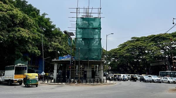
Chomu Pulia Circle — one of northern Jaipur’s most important and most widely recognised traffic junctions — is a prominent roundabout and bus terminal intersection on NH-52 (Sikar Road) in the Jhotwara–Vidyadhar Nagar belt of Jaipur’s expanding northern urban zone. The name “Pulia” derives from the Rajasthani word for a bridge or flyover, and indeed the circle is defined by its elevated flyover structure that carries Sikar Road traffic smoothly over the junction, reducing the congestion that once characterised this critical gateway between central Jaipur and the north of the city. Chomu Pulia is the point from which NH-52 fans northward toward the towns of Chomu, Renwal, and Sikar — making it the primary departure reference point for all northbound road travel out of Jaipur — while simultaneously serving as a major node for JCTSL (Jaipur City Transport Services Limited) city bus routes, Rajasthan Roadways intercity services, and daily commuters from the Vidyadhar Nagar, Jhotwara, and Ambabari residential belts.
Chomu Pulia Circle Location
- Address: Chomu Pulia Circle, Jhotwara Road / NH-52 (Sikar Road), Ambabari, Jaipur, Rajasthan — 302039
- Pin Code: 302039
- Administrative Zone: Jaipur City Division — Rajasthan Postal Circle
- Coordinates: 26°56’30.5″N, 75°46’24.3″E
| Reference Point | Distance |
| Dahar Ka Balaji Railway Station | 780 metres (1 km northwest) |
| Jaipur Junction Railway Station | 2.5 kilometres |
| Jaipur Metro — Railway Station Metro | 3 kilometres |
| Vidyadhar Nagar | 2 kilometres |
| Jhotwara | 3 kilometres |
| Ambabari | 1 kilometre |
| VKI (Vishwakarma Industrial Area) | 4 kilometres |
| Cinepolis Cinema | Adjacent |
| Maharishi Arvind Institute of Science & Management | Adjacent |
| Jaipur International Airport | 12 kilometres |
| Chomu Town | 35 kilometres |
| Sikar | 110 kilometres |
Directions to Chomu Pulia Circle
From Jaipur Junction Railway Station
Take Station Road northward → continue via Sindhi Camp → proceed north on Jhotwara Road / NH-52 (Sikar Road) → Chomu Pulia Circle is approximately 2.5 kilometres — 10 to 15 minutes by auto-rickshaw or city bus.
From Jaipur International Airport
Take NH-48 toward the city → proceed via Durgapura or Tonk Road → connect to MI Road and continue northward → take Jhotwara Road via Sindhi Camp toward NH-52 → Chomu Pulia Circle approximately 12 kilometres — 25 to 40 minutes by road depending on traffic.
From Ajmeri Gate / Old City
Take MI Road northward → continue via GPO and Chandpole → take Jhotwara Road northward → continue on NH-52 → Chomu Pulia Circle approximately 6 kilometres — 15 to 20 minutes.
From VKI (Vishwakarma Industrial Area)
Take Road No. 17 eastward toward NH-52 → Chomu Pulia Circle approximately 4 kilometres — 10 to 15 minutes.
From Chomu Town
Take NH-52 southward toward Jaipur — approximately 35 kilometres — Chomu Pulia Circle is the first major Jaipur city junction encountered — approximately 45 to 60 minutes.
Road Connectivity Chomu Pulia Circle
| Road | Direction | Connectivity |
| NH-52 (Sikar Road) | North toward Chomu, Renwal, Sikar | Sikar, Churu, North Rajasthan |
| Jhotwara Road | South toward city centre | Sindhi Camp, Ajmeri Gate, MI Road |
| Ambabari Road | East to Ambabari | Ambabari residential belt |
| VKI Road (Road No. 17) | West toward VKI | Vishwakarma Industrial Area |
| Ring Road (Jaipur) | East–West connector | Jaipur city ring — Narayan Singh Circle, Gopalpura |
| Jaipur–Agra Road (via connector) | East | National Highway toward Agra |
The Chomu Pulia flyover (puliya) — the elevated structure from which the circle takes its name — carries NH-52 traffic over the junction, significantly reducing congestion at what was historically one of the city’s most choked intersections.
JCTSL City Bus Connectivity Chomu Pulia Circle
| JCTSL Route | Service Details |
| Route 1 / 1A | Todi to Transport Nagar — via Chomu Pulia, Pittal Factory, Chandpole, GPO, MI Road |
| Route 1A | VKI Road No. 17 to Transport Nagar — via Chomu Pulia, Amba Badi, Chandpole, GPO |
| Route 6 / 6A (Jhotwara) | Chomu Pulia, Jhotwara — via city centre routes |
| Route 8A | Jagatpura to Chomu Puliya — via Apex Circle, Rambhag, MI Road, Sindhi Camp, Chinkara — 18 stops |
| Route 8B | Alka Cinema to Jagatpura — via Vidyadhar Nagar, Jhotwara, Chandpole — 36 stops |
| Rajasthan Roadways (RSRTC) | Intercity — Chomu, Renwal, Sikar, Churu, Jhunjhunu direction |
| Private Buses | Multiple operators — Sikar Road northbound |
Railway Connectivity Chomu Pulia Circle
| Station | Distance | Line | Notes |
| Dahar Ka Balaji Railway Station | 780 metres (1 km NW) | Jaipur–Churu broad-gauge section | Nearest station — small halt |
| Jaipur Junction Railway Station | 2.5 km | North Western Railway — NWR | Main Jaipur terminus — all major trains |
| Gandhinagar (Jaipur) Station | 3 km | North Western Railway | Suburban access |
Metro Connectivity Chomu Pulia Circle
Jaipur Metro’s Pink Line — East-West Corridor — has its Railway Station Metro Station approximately 3 kilometres from Chomu Pulia Circle. The Metro station connects directly to Jaipur Junction Railway Station (opened June 3, 2015), making bus-to-Metro transfer via the Railway Station the most practical rapid transit connection for Chomu Pulia commuters heading into central Jaipur.
Nearby Areas and Landmarks Chomu Pulia Circle
| Landmark / Area | Distance | Description |
| Dahar Ka Balaji Railway Station | 780 metres | Nearest railway halt — Jaipur–Churu section |
| Jaipur Junction | 2.5 km | Main railway terminus for all Jaipur trains |
| Cinepolis Cinema (Jaipur) | Adjacent | Multiplex cinema directly at Chomu Pulia |
| Maharishi Arvind Institute of Science & Management | Adjacent | College adjacent to the circle |
| Ambabari Residential Area | 1 km | Dense residential belt of north Jaipur |
| Vidyadhar Nagar | 2 km | Planned residential neighbourhood — well-developed |
| Jhotwara Industrial Area | 3 km | Manufacturing and small industry cluster |
| VKI — Vishwakarma Industrial Area | 4 km | Jaipur’s major industrial estate |
| Amber Fort | 10 km | UNESCO World Heritage Site — via Ring Road northeast |
| Jal Mahal | 8 km | Iconic Jaipur landmark — Man Sagar Lake |
Frequently Asked Questions (FAQs)
Q1. What does “Pulia” mean in Chomu Pulia?
A: “Pulia” means a bridge or flyover in Rajasthani/Hindi. The name refers to the elevated flyover structure on NH-52 that defines and names this junction.
Q2. Which railway station is nearest to Chomu Pulia Circle?
A: Dahar Ka Balaji Railway Station is 780 metres away — the closest halt. Jaipur Junction is 2.5 kilometres south — the main station for all major trains.
Q3. Which JCTSL bus routes serve Chomu Pulia?
A: Routes 1, 1A, 6, 8A, and 8B are the primary JCTSL routes. Route 8A runs Jagatpura to Chomu Puliya covering 18 stops. Rajasthan Roadways intercity buses also depart from this point toward Chomu, Sikar, and Churu.
Q4. How far is Jaipur Metro from Chomu Pulia Circle?
A: The nearest Metro station (Railway Station Metro on the Pink Line) is approximately 3 kilometres south — the most practical rapid transit option from this circle.
Q5. How far is Chomu town from Chomu Pulia Circle?
A: Approximately 35 kilometres north via NH-52 — 45 to 60 minutes by road.
Q6. Is there a cinema near Chomu Pulia?
A: Yes. Cinepolis is located directly adjacent to Chomu Pulia Circle — one of the most prominent entertainment landmarks at this junction.
Q7. What is the PIN code of Chomu Pulia Circle?
A: The PIN code is 302039, falling under the Jaipur City Division of Rajasthan Postal Circle.
Q8. How do I reach Chomu Pulia from Jaipur Junction?
A: Take JCTSL Route 1, 1A, or 8A northbound from Jaipur Railway Station toward Jhotwara Road — the journey takes approximately 10 to 15 minutes by city bus.