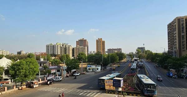
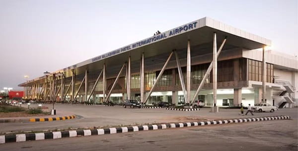
Airport Circle — the prominent roundabout junction in Sardarnagar, Hansol, Ahmedabad — is one of the most transitionally vital intersections in the entire Ahmedabad metropolitan region. Named for its defining geographic relationship with the Sardar Vallabhbhai Patel International Airport (AMD), which it directly serves, Airport Circle is the primary transit and navigation reference point for all road traffic approaching or departing from Ahmedabad’s international and domestic air terminal. Sardarnagar is the locality that flanks the Airport Road on its approach to the terminal — its residential and commercial character shaped entirely by its proximity to one of India’s busiest and fastest-growing airports — making Airport Circle not just a navigation landmark but the geographic anchor of the entire airport zone.
Location of Airport Circle
- Address: Airport Circle, Sardarnagar, Hansol, Ahmedabad, Gujarat — 382475
- Pin Code: 382475
- Post Office: Sardarnagar
- STD Code: 079
- Administrative Zone: Jamalpur Ward — Ahmedabad Municipal Corporation (AMC)
| Reference Point | Distance |
| Sardar Vallabhbhai Patel International Airport (AMD) | 493 metres (7-minute walk) |
| Ahmedabad Domestic Airport Terminal | 837 metres (11-minute walk) |
| Sardarnagar Bus Stop | 839 metres |
| Talavadi Circle | 628 metres |
| Hansol | 1 kilometre |
| Naroda | 5 kilometres |
| Ahmedabad Railway Station (Kalupur) | 12 kilometres |
| Lal Darwaja (City Centre) | 13 kilometres |
| Ahmedabad One Mall | 8 kilometres |
Airport Circle’s proximity to the airport terminal — under 500 metres — makes it the single most airport-adjacent major roundabout in Ahmedabad’s road network, and effectively the last landmark before the terminal gate for the vast majority of road travellers.
Directions to Airport Circle
From Ahmedabad Railway Station (Kalupur)
Take Ashram Road northward → continue via Relief Road → take SP Ring Road north connector → follow Airport Road (NH-47 / SH-17 Airport connector) toward Hansol → Airport Circle is approximately 12 kilometres — 20 to 30 minutes by road.
From Lal Darwaja (City Centre)
Take Ashram Road north → continue on NH-47 / SH-17 → follow Airport Road toward Hansol → Airport Circle approximately 13 kilometres — 25 to 35 minutes.
From Maninagar
Take NH-228 north → connect to SP Ring Road west → follow Airport Road toward Hansol → Airport Circle approximately 18 kilometres — 30 to 40 minutes.
From Gandhinagar
Take NH-48 southward toward Ahmedabad → exit onto SP Ring Road / Hansol connector → follow Airport Road toward the terminal → Airport Circle approximately 15 kilometres — 20 to 30 minutes.
From Naroda
Take Naroda–Hansol Road westward → approximately 5 kilometres → Airport Circle. 10 to 15 minutes.
Road Connectivity of Airport Circle
| Road | Direction | Connectivity |
| Airport Road (SH-17 / NH-47 connector) | South toward city centre | Lal Darwaja, Ashram Road, Ahmedabad station |
| Airport Road — Terminal approach | North (500 m) | Sardar Vallabhbhai Patel International Airport |
| Hansol Road | East | Hansol, Naroda corridor |
| SP Ring Road (132 Feet Road) | East–West circular | Ring road — Naroda, Thaltej, Sarkhej |
| NH-47 / NH-8A | South–West | Ahmedabad–Mumbai Highway |
| Sardarnagar Road | Adjacent | Sardarnagar residential area |
AMTS City Bus Connectivity of Airport Circle
| AMTS Route | Service Details |
| Route 15D | Iskcon Cross Road to Ahmedabad Domestic Airport — last bus at the airport 11:25 PM |
| Route 15U | Iskcon Cross Road — via Airport Circle corridor |
| Route 18D | Maninagar to Ahmedabad Domestic Airport — via Airport Circle |
| Route 18E | Ahmedabad Domestic Airport to Shastrinagar — via Airport Circle |
| Route 18S | Pragatinagar to Ahmedabad Domestic Airport |
| Route 18U | Maninagar — first bus at Airport zone at 6:00 AM |
| Route 16 | Vatva Railway Crossing to Someshwar Mahadev — via Airport Circle |
| Route 103 | Naroda Gam to Gujarat University — via Airport Circle |
| Route 105 | Lal Darwaja to Naroda Industrial Township — via Airport Circle |
| Route 106 | Sarangpur to Sarangpur via Naroda — via Airport Circle |
| Route 107 | Sarangpur to Sarangpur via Ajit Mill, Naroda, Camp Sadar Bazar |
| Route 122 / 126 | Via Airport Circle — Sarangpur corridor |
First AMTS service: Route 18U at 6:00 AM. Last AMTS service: Route 15D at 11:25 PM.
Railway Connectivity of Airport Circle
| Station | Distance | Line | Notes |
| Ahmedabad Railway Station (Kalupur) | 12 km | All lines | Main Ahmedabad terminus |
| Sabarmati Junction | 8 km | Western Railway | Junction station — multiple lines |
| Chandkheda Road Station | 10 km | Western Railway suburban | Northern suburban access |
Metro Connectivity of Airport Circle
The Ahmedabad Metro network does not yet have a station at Airport Circle directly. However, the Gujarat Metro Rail Corporation (GMRCL) has infrastructure aligned with the airport zone, and the planned Airport Metro Station as part of the expanding Metro network will provide direct Metro connectivity to the Airport Circle area in the near future.
Nearby Areas and Landmarks of Airport Circle
| Landmark / Area | Distance | Description |
| Sardar Vallabhbhai Patel International Airport (AMD) | 493 metres | International and domestic terminal — one of India’s busiest airports |
| Ahmedabad Domestic Airport Terminal | 837 metres | Domestic terminal access |
| Sardarnagar Residential Area | Adjacent | Residential colony flanking Airport Road |
| Talavadi Circle | 628 metres | Secondary junction near the airport zone |
| Hansol Village | 1 km | Historic village settlement — origin of the Hansol locality name |
| Naroda Industrial Area | 5 km | Major GIDC industrial estate |
| Hotel Zone (Airport Road) | Adjacent | Hotels serving airport travellers — Novotel, Hyatt, and others on Airport Road |
Frequently Asked Questions (FAQs)
Q1. How far is Airport Circle from Ahmedabad Airport?
A: Airport Circle is just 493 metres from the Sardar Vallabhbhai Patel International Airport — a 7-minute walk — making it the closest major roundabout to the terminal.
Q2. Which AMTS routes serve Airport Circle?
A: Routes 15D, 15U, 16, 18D, 18E, 18S, 18U, 103, 105, 106, 107, 122, and 126 all serve the Airport Circle and Airport Road corridor.
Q3. What time is the first and last AMTS bus at Airport Circle?
A: First bus is Route 18U at 6:00 AM. Last bus is Route 15D at 11:25 PM.
Q4. How far is Airport Circle from Ahmedabad Railway Station?
A: Approximately 12 kilometres — 20 to 30 minutes by road via Ashram Road and NH-47.
Q5. Is there Metro connectivity at Airport Circle?
A: No direct Metro station yet. A planned airport Metro station under GMRCL expansion will provide future direct Metro access to this zone.
Q6. What is the PIN code of Airport Circle, Sardarnagar, Hansol?
A: The PIN code is 382475, with the Sardarnagar post office as the head office.
Q7. Which hotels are near Airport Circle, Hansol?
A: Several business and transit hotels are located directly on Airport Road adjacent to the circle — including Novotel Ahmedabad and Hyatt Regency — catering to air travellers and business guests.
Q8. How far is Naroda from Airport Circle?
A: Approximately 5 kilometres via the Hansol–Naroda Road — 10 to 15 minutes by road.