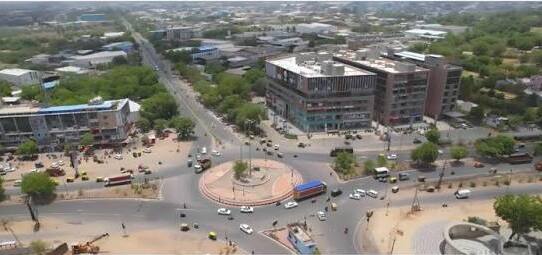
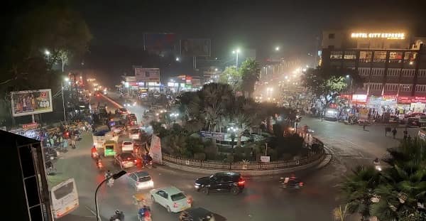
Koba Circle — the prominent roundabout junction at the Koba village crossing in Gandhinagar district, Gujarat — is one of the most strategically significant transit and navigation junctions on the Ahmedabad–Gandhinagar corridor, positioned at the precise geographic midpoint where the Sarkhej–Gandhinagar Highway (NH-147 / SH-71) intersects with the Koba–Adalaj Road and the Gandhinagar–Ahmedabad Road. The circle is the primary navigation reference for the rapidly growing Koba locality — which has seen explosive residential development since the metro arrived — and is widely known as the transit gateway to two of Gujarat’s most important institutions: Pandit Deendayal Energy University (PDPU, formerly PDPU / PDEU), one of India’s premier energy and technology universities, and GIFT City (Gujarat International Finance Tec-City), India’s first operational smart city and international financial hub, approximately 8 kilometres east. Koba Circle now has a dedicated Metro station — Koba Circle Metro Station on Gujarat Metro Line 3 — with the Narmada Canal Metro Station just 8 minutes’ walk away, making it one of the most Metro-proximate circles in the Ahmedabad–Gandhinagar Metro corridor.
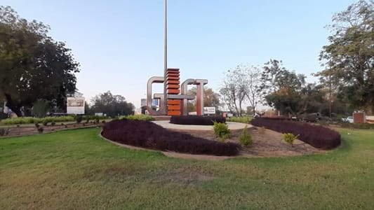
Koba Circle Location
Address: Koba Circle, Gandhinagar–Ahmedabad Road (SH-71 / NH-147), Koba, Gandhinagar District, Gujarat — 382426
Pin Code: 382426
Post Office: Adalaj
STD Code: 02716
Administrative Zone: Gandhinagar North Assembly Constituency — Gandhinagar District
| Reference Point | Distance |
| PDPU (Pandit Deendayal Energy University) | 300 metres — adjacent |
| Koba Circle Metro Station (Line 3) | 8-minute walk |
| Narmada Canal Metro Station (Line 3) | 8-minute walk |
| GIFT City | 8 kilometres |
| Adalaj Circle | 6 kilometres |
| Gandhinagar Capital Complex | 10 kilometres |
| Sardar Vallabhbhai Patel International Airport | 10 kilometres |
| Ahmedabad Railway Station (Kalupur) | 20 kilometres |
| Lal Darwaja (City Centre) | 15 kilometres |
| Chandkheda | 8 kilometres |
| Shri Mahavir Jain Aradhana Kendra | Adjacent — Koba Tirth |
| Ahmedabad Bus Station (Geeta Mandir) | 25 kilometres |
Directions to Koba Circle
From Ahmedabad Railway Station (Kalupur)
Take Ashram Road northward → continue on NH-147 / SH-71 (Ahmedabad–Gandhinagar Road) northeastward → Koba Circle approximately 20 kilometres — 30 to 40 minutes by road.
From Sardar Vallabhbhai Patel International Airport
Exit onto NH-147 → take SH-71 (Sarkhej–Gandhinagar Highway) northward → approximately 10 kilometres → Koba Circle. 15 to 20 minutes.
From Gandhinagar Capital Complex
Take Sarkhej–Gandhinagar Highway (NH-147) southward → approximately 10 kilometres → Koba Circle. 15 to 20 minutes.
From Adalaj Circle
Take SH-71 northeastward → approximately 6 kilometres → Koba Circle. 10 to 12 minutes.
From GIFT City
Take the GIFT City access road westward → connect to Koba–Gandhinagar Road → approximately 8 kilometres → Koba Circle. 12 to 18 minutes.
Road Connectivity
| Road | Direction | Connectivity |
| Sarkhej–Gandhinagar Highway (NH-147 / SH-71) | North toward Gandhinagar | Gandhinagar Capital, Sector zones |
| SH-71 — Southbound | South toward Ahmedabad | Adalaj, Airport, Chandkheda, Ahmedabad city |
| Koba–Adalaj Road | West toward Adalaj | Adalaj Circle, Adalaj Stepwell |
| Koba–Gandhinagar Road | Northeast toward Gandhinagar | GIFT City connector, Kudasan, Randesan |
| Raysan Road | West toward Raysan | PDPU Circle zone, Raysan Petrol Pump |
| PDPU Cross Road | Internal — PDPU campus | Pandit Deendayal Energy University |
AMTS and Bus Connectivity
| Route | Service Details |
| AMTS Route 102 | Maninagar Terminal to Akshardham Mandir (Gandhinagar) — via Koba Circle — first bus 6:55 AM, last 10:15 PM |
| AMTS Route 102 | Lal Darwaja to Akshardham Mandir (Gandhinagar) — via Koba Circle |
| AMTS Route 101-SH | Asarva Railway Station to PDPU Cross Road — via Koba Circle |
| GSRTC | Intercity buses — Ahmedabad to Gandhinagar via Koba Circle — all services passing on SH-71 |
| GIFT Metro Feeder Bus | Feeder connectivity from Koba Circle Metro to GIFT City zone |
| Auto-Rickshaw | Available throughout the day at the circle |
| App-Based Cab | Ola, Uber active in the area |
First bus service: Route 102 at 6:55 AM. Last bus service: Route 102 at 10:15 PM.
Koba Circle Metro Connectivity
Koba Circle is one of the few major Gujarat highway junctions with its own dedicated Metro station. Koba Circle Metro Station on Gujarat Metro Line 3 (Motera Stadium–Sachivalaya corridor) is the nearest stop — 8-minute walk from the circle — with the first Line 3 Metro at 8:20 AM and the last at 8:24 PM. The Narmada Canal Metro Station is equally close at 8 minutes’ walk. The Metro Line 3 connects Koba Circle to the Motera Stadium (Narendra Modi Stadium) zone in the south and toward Gandhinagar Sachivalaya in the north — giving this highway circle a rapid transit connectivity that significantly enhances its real estate and institutional appeal.
Koba Circle Railway Connectivity
| Station | Distance | Line | Notes |
| Medra Railway Station | 4 km | Western Railway — suburban | Nearest rural halt station |
| Naroda Railway Station | 6 km | Western Railway | Suburban access |
| Ahmedabad Railway Station (Kalupur) | 20 km | All lines | Main Ahmedabad terminus |
Nearby Areas and Landmarks
| Landmark / Area | Distance | Description |
| PDPU (Pandit Deendayal Energy University) | 300 metres | India’s premier energy and petroleum technology university |
| Shri Mahavir Jain Aradhana Kendra (Koba Tirth) | Adjacent | Sacred Jain pilgrimage centre and meditation ashram |
| GIFT City (Gujarat International Finance Tec-City) | 8 km | India’s first operational smart city and IFSC — major financial hub |
| Koba Circle Metro Station (Line 3) | 8-minute walk | Gujarat Metro Line 3 — Motera–Sachivalaya corridor |
| Kudasan | 3 km | Growing residential locality adjacent to Koba |
| Randesan | 4 km | Gandhinagar planned residential zone — Simandhar City |
| Adalaj Stepwell | 7 km | UNESCO-recognised 15th-century heritage stepwell |
| Gandhinagar Capital | 10 km | Gujarat state capital — legislative and administrative complex |
| Ahmedabad Airport | 10 km | Direct NH-147 access |
Frequently Asked Questions (FAQs)
Q1. Where is Koba Circle located?
Koba Circle is on SH-71 / NH-147 (Ahmedabad–Gandhinagar Road), Koba, Gandhinagar District — PIN 382426 — at the intersection of the Sarkhej–Gandhinagar Highway and the Koba–Adalaj and Koba–Gandhinagar Roads.
Q2. Is there a Metro at Koba Circle?
Yes. Koba Circle Metro Station on Gujarat Metro Line 3 (Motera Stadium–Sachivalaya) is approximately an 8-minute walk — first Metro at 8:20 AM, last at 8:24 PM.
Q3. How far is PDPU from Koba Circle?
Pandit Deendayal Energy University (PDPU) is approximately 300 metres from the circle — effectively adjacent to it.
Q4. Which AMTS routes serve Koba Circle?
Route 102 (Maninagar Terminal / Lal Darwaja to Akshardham Mandir Gandhinagar) and Route 101-SH (Asarva to PDPU) serve Koba Circle — first bus 6:55 AM, last 10:15 PM.
Q5. How far is GIFT City from Koba Circle?
Approximately 8 kilometres via the Koba–Gandhinagar Road — 12 to 18 minutes by road.
Q6. How far is Ahmedabad Airport from Koba Circle?
Approximately 10 kilometres via NH-147 southward — 15 to 20 minutes by road.
Q7. What is the Koba Tirth near Koba Circle?
Shri Mahavir Jain Aradhana Kendra — Koba Tirth — is a significant Jain pilgrimage and meditation centre located directly adjacent to Koba Circle, drawing devotees from across Gujarat and nationally.
Q8. How far is Gandhinagar from Koba Circle?
Approximately 10 kilometres north via SH-71 / NH-147 — 15 to 20 minutes by AMTS bus Route 102 or cab.