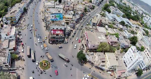
Rau Circle — the principal roundabout junction in Rau, a rapidly growing suburb of Indore city in Madhya Pradesh — is one of the most important highway transit junctions on the Agra–Bombay Road (A.B. Road / NH-52, formerly NH-3) in the Indore Metropolitan Region. Rau, a Nagar Panchayat in Indore district, has grown from an agricultural village on the Mumbai–Agra road into one of Indore’s most educationally and industrially dense suburban towns — hosting the campus of Indian Institute of Management Indore (IIM Indore), Raja Ramanna Centre for Advanced Technology (RRCAT) engaged in laser and nuclear science research, the State Institute of Hotel Management, and a cluster of engineering and management colleges affiliated to Devi Ahilya Vishwavidyalaya. Rau Circle is the primary navigation landmark of the town, sitting on NH-52 between Mhow and Rajendra Nagar (Indore) — and also serving as a designated FlixBus boarding and dropping point for intercity AC bus services. AiCTSL (Atal Indore City Transport Services Limited) city buses depart from Rau Bus Stand to Indore city every 15 minutes, making the circle one of the most frequently served suburban transit points in the Indore metropolitan zone.
Rau Circle Location
- Address: Rau Circle, Agra–Bombay Road (NH-52 / A.B. Road), Rau, Indore District, Madhya Pradesh — 453331
- Pin Code: 453331
- Post Office: Rau
- STD Code: 0731
- Administrative Zone: Rau Assembly Constituency — Indore District, Madhya Pradesh
| Reference Point | Distance |
| Rau Railway Station (Rau Halt) | 700 metres |
| Rau Bus Stand (AiCTSL) | Adjacent |
| IIM Indore Campus | 3 kilometres |
| State Institute of Hotel Management Indore | 3 kilometres (via Rau Bypass) |
| Raja Ramanna Centre for Advanced Technology (RRCAT) | 4 kilometres |
| Pithampur Industrial Area (via CAT Road) | 15 kilometres |
| Indore City Centre | 11 kilometres (7 miles) |
| Indore Junction Railway Station | 14 kilometres |
| Devi Ahilyabai Holkar Airport, Indore | 16 kilometres |
| Mhow | 12 kilometres |
| Rajendra Nagar, Indore | 5 kilometres |
| Rangwasa Village | Adjacent |
Directions to Rau Circle
From Indore Junction Railway Station
Take AB Road (NH-52) southwestward → continue via Rajendra Nagar and the Indore–Rau corridor → approximately 14 kilometres — 20 to 30 minutes by road or AiCTSL city bus.
From Devi Ahilyabai Holkar Airport, Indore
Take Airport Road toward the city → join AB Road (NH-52) southwestward → continue past Rajendra Nagar → Rau Circle approximately 16 kilometres — 20 to 30 minutes.
From Indore City Centre (Sarwate Bus Stand)
Take AiCTSL city bus from Chameli Devi School / Sarwate area → Rau Bus Stand via AB Road — 19 minutes, buses every 15 minutes throughout the day.
From Mhow
Take AB Road (NH-52) northeastward → approximately 12 kilometres → Rau Circle. 15 to 20 minutes.
From Pithampur Industrial Area
Take the CAT Road (Rau–CAT Road / Pithampur Road) → approximately 15 kilometres → Rau Circle. 20 to 30 minutes.
Road Connectivity Rau Circle
| Road | Direction | Connectivity |
| Agra–Bombay Road (NH-52 / A.B. Road) | Northeast toward Indore city | Rajendra Nagar, Indore city centre, Agra (north) |
| NH-52 / A.B. Road — Southwestward | Southwest toward Mhow | Mhow Cantonment, Mahow town, Khandwa direction |
| CAT Road (Rau–Pithampur Road) | West toward Pithampur | Pithampur Industrial Area — Dhar, Dewas |
| Rangwasa Road | North | Rangwasa village, IIM Indore approach |
| Rau Bypass Road | South | Rau Bypass Square, Jai Mata Di Toll, NH-3 |
| NH-52 / Indore–Khandwa Road | East via connectors | Khandwa, Burhanpur |
AiCTSL and City Bus Connectivity Rau Circle
| Route / Service | Service Details |
| AiCTSL City Bus — Indore to Rau | Departs Chameli Devi School / Sarwate Bus Stand every 15 minutes — fare ₹10–₹15 — journey 19 minutes — operates daily |
| AiCTSL City Bus — Rau to Indore | Departs Rau Bus Stand to Chameli Devi School — every 15 minutes — 19 minutes journey |
| AiCTSL — Rau to Mhow | Regular AiCTSL services via AB Road toward Mhow Cantonment |
| FlixBus — Rau Circle (N) and (S) | Intercity AC bus boarding and dropping — Indore to Mumbai, Pune, Bhopal directions — Rau Circle officially designated FlixBus stop |
| Private City Buses / Minibuses | Rau–Indore corridor — frequent private operators |
| Auto-Rickshaw | Available throughout the day at Rau Circle and Bus Stand |
| App-Based Cab | Ola, Uber active — Rau–Indore corridor |
AiCTSL service frequency: Every 15 minutes throughout the day between Rau and Indore city.
Railway Connectivity Rau Circle
| Station | Distance | Line | Notes |
| Rau Railway Station (Rau Halt) | 700 metres | Akola–Ratlam Line (South Central Railway) | Nearest station — small halt with limited services |
| Rajendra Nagar Railway Station | 5 km | Akola–Ratlam Line | Additional halt |
| Indore Junction Railway Station | 14 km | Western Railway — major junction | Main Indore terminus — all express and passenger trains |
Metro Connectivity Rau Circle
Indore does not currently have an operational Metro system as of 2026. The Indore Metro project — two proposed corridors — is under active development, and the AB Road corridor (which passes through Rau) is one of the proposed Metro alignments. If sanctioned and executed, this would bring a Metro station to the Rau Circle zone, dramatically enhancing rapid transit connectivity between Rau and Indore city. Until then, AiCTSL city buses remain the primary rapid public transit option.
Nearby Areas and Landmarks Rau Circle
| Landmark / Area | Distance | Description |
| IIM Indore Campus | 3 km | Indian Institute of Management — one of India’s top-ranked management institutes |
| Raja Ramanna Centre for Advanced Technology (RRCAT) | 4 km | Prestigious DAE research centre — laser and nuclear science |
| State Institute of Hotel Management Indore | 3 km | Via Rau Bypass — premier hotel management institute |
| Rau Railway Station | 700 metres | Nearest rail access — Akola–Ratlam passenger services |
| Medi-Caps Group of Institutions | Within Rau zone | Engineering and management college cluster |
| Sanghvi Institute of Management and Science | Within Rau zone | Engineering college on Pigdambar Road |
| Indore Institute of Science and Technology | Within Rau zone | Technical college |
| Pithampur Industrial Area | 15 km | One of Madhya Pradesh’s largest MIDC industrial zones — Mahindra, Eicher, Cipla, and others |
| Emerald Heights International School | Within Rau | CBSE school in the Rau locality |
| Mhow Cantonment | 12 km | Historic military cantonment town |
Frequently Asked Questions (FAQs)
Q1. Where is Rau Circle located in Madhya Pradesh?
A: Rau Circle is on AB Road (NH-52 / Agra–Bombay Road) in Rau — a suburb of Indore city — PIN 453331 — approximately 11 kilometres southwest of Indore city centre.
Q2. How frequently do AiCTSL buses run from Rau Circle to Indore?
A: AiCTSL city buses depart every 15 minutes from Rau Bus Stand to Indore (Chameli Devi School / Sarwate area) — the journey takes approximately 19 minutes.
Q3. Is IIM Indore near Rau Circle?
A: Yes. Indian Institute of Management Indore campus is approximately 3 kilometres from Rau Circle — accessible by auto-rickshaw or cab in 5 to 8 minutes.
Q4. Which railway station is nearest to Rau Circle?
A: Rau Railway Station (Rau Halt) is approximately 700 metres away on the Akola–Ratlam line. Indore Junction — the main terminus for all express trains — is 14 kilometres away.
Q5. Is there Metro at Rau Circle, Madhya Pradesh?
A: No operational Metro yet. The Indore Metro project includes a proposed corridor along the AB Road alignment which would serve Rau — but a confirmed opening timeline is not yet established as of 2026.