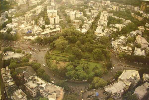
King Circle — known officially as Maheshwari Udyan (though universally called King’s Circle by Mumbaikars) — is one of central Mumbai’s most historically rooted, most institutionally significant, and most multi-modal transit junctions, sitting at the intersection of the Matunga (East) zone, Sion Koliwada, and the Harbour Line railway corridor in the heart of the Matunga neighbourhood. The park at King’s Circle was originally named after King George V — the King-Emperor of the British Indian Empire — with the word “Circle” reflecting the circular layout of the original Elphinstone-era planned open space, a design legacy shared with Horniman Circle in Fort. The circle is surrounded by one of Mumbai’s most distinctive cultural and demographic landscapes — Matunga is celebrated across India as Mumbai’s “South Indian Colony,” with Tamil, Telugu, and Kannada-speaking communities maintaining an unbroken cultural presence here since the early 20th century, and the Matunga market area adjacent to King’s Circle remains one of Mumbai’s most beloved destinations for authentic South Indian street food, Udupi restaurants, and traditional grocery stores. King’s Circle HARBOUR LINE Railway Station is the defining transit landmark of the junction — with trains on the Harbour Line (Chhatrapati Shivaji Maharaj Terminus–Panvel) stopping here. BEST buses include Routes 66, A-25, 7LTD, 85, A-5, A-21, 8LTD, A-92, and more, with the first bus (C-521) departing at 5:19 AM.
King Circle, Mumbai Location
Address: King’s Circle (Maheshwari Udyan), Dr. Babasaheb Ambedkar Road / LJ Road, Sion Koliwada / Matunga (East), Mumbai — 400019, Maharashtra
Pin Code: 400019
STD Code: 022
Administrative Zone: F/North Ward — Brihanmumbai Municipal Corporation (BMC) / Matunga (East)
| Reference Point | Distance |
| King’s Circle (Maheshwari Udyan) Bus Stop | At the circle — 2-minute walk |
| King’s Circle Railway Station (Harbour Line) | 10-minute walk |
| Matunga Road Railway Station (Western Line) | 25-minute walk |
| Matunga Railway Station (Central Line) | 26-minute walk |
| Guru Tegh Bahadur Nagar Railway Station (Harbour Line) | 11-minute walk |
| Acharya Atre Nagar Monorail Station | 11-minute walk |
| Dadar Railway Station | 2 kilometres |
| Sion Railway Station | 2 kilometres |
| Chhatrapati Shivaji Maharaj International Airport | 7 kilometres |
| CSMT (Chhatrapati Shivaji Maharaj Terminus) | 7 kilometres |
| Gandhi Market, Matunga | 6-minute walk |
Directions to King Circle
From CSMT (South Mumbai)
Take Harbour Line local train from CSMT toward Panvel → alight at King’s Circle Station → 10-minute walk to the circle. Total journey approximately 20 to 25 minutes.
From Dadar
Take auto-rickshaw or BEST bus eastward from Dadar → approximately 2 kilometres — 5 to 10 minutes via Dr. B.A. Road.
From Sion
Take BEST Route 66 or auto-rickshaw northward → approximately 2 kilometres — 5 to 8 minutes.
From Chhatrapati Shivaji Maharaj International Airport
Take a cab via Eastern Express Highway or Western Express Highway → approximately 7 kilometres — 20 to 35 minutes.
From Matunga (Central Line)
Walk eastward from Matunga Central Station → approximately 1.5 kilometres — 20-minute walk or 5-minute auto.
King Circle, Mumbai Road Connectivity
| Road | Direction | Connectivity |
| Dr. Babasaheb Ambedkar Road | North–South | Dadar (north) — Sion, Chembur (south) |
| LJ Road (Lokmanya Tilak Road) | East–West | Matunga Market, Matunga Central Station (west) — Sion (east) |
| Dharavi Road | North | Dharavi, Bandra–Kurla Complex (BKC) |
| Tilak Road (Acharya Tilak Road) | West | Matunga residential belt, Ruia College area |
| Eastern Express Highway | East via Sion | CSMT, Navi Mumbai, Thane |
| Sion-Bandra Link Road | North | Bandra, Western suburbs |
BEST Bus Connectivity
| BEST Route | Service Details |
| Route 66 | Via Maheshwari Udyan (King’s Circle) — Rani Laxmibai Chowk Sion to Ballard Pier — direct service |
| Route A-25 | Via King’s Circle — Backbay Depot to Kurla / Rani Laxmibai Chowk Sion |
| Route 7LTD / 8LTD | LTD services via King’s Circle zone |
| Route A-5 | Via King’s Circle — Kurla Bus Station (E) to Mantralaya / Hutatma Chowk |
| Route A-21 | Via King’s Circle — Deonar / Trombay to Dr. Shyamaprasad Mukherjee Chowk |
| Route 85 | Via King’s Circle — Kurla Bus Station (E) to Pandit Paluskar Chowk (Opera House) |
| Route A-92 | Via King’s Circle — Anushakti Nagar / Deonar to Vasantrao Naik Chowk (Tardeo) |
| Route A-171 | Via King’s Circle — Worli Depot to Chunabhatti |
| Route C-305 | Via King’s Circle — Backbay Depot to Dharavi Depot |
| Route A-351 / A-354 / A-357 | Via King’s Circle zone |
| Route 9 | Via King’s Circle Flyover — Antop Hill Bus Station |
| Route 25LTD / 22LTD | Via King’s Circle zone |
| Route C-521 | First bus near King’s Circle at 5:19 AM |
First BEST bus: Route C-521 at 5:19 AM. Services operate through the day and late night.
King Circle, Mumbai Railway Connectivity
| Station | Distance | Line | Notes |
| King’s Circle Railway Station | 10-minute walk | Harbour Line (CR) | Harbour Line — CSMT to Panvel / Vashi |
| Guru Tegh Bahadur Nagar Station | 11-minute walk | Harbour Line | Adjacent Harbour Line stop |
| Matunga Road Station | 25-minute walk | Western Railway | WR suburban access |
| Matunga Station | 26-minute walk | Central Railway | CR Main Line access |
| Dadar Station | 2 km | Central + Western Railway | Major interchange — both CR and WR |
King Circle, Mumbai Metro and Monorail Connectivity
Acharya Atre Nagar Monorail Station on the Mumbai Monorail (Wadala–Jacob Circle corridor) is approximately 11 minutes’ walk from King’s Circle — providing Monorail connectivity to Wadala, Chembur, and the east. Mumbai Metro Line 11 (Wadala–CSMT–Horniman Circle corridor) is planned to include stations serving the King’s Circle–Matunga zone — which would bring underground Metro access in the future.
King Circle, Mumbai Nearby Areas and Landmarks
| Landmark / Area | Distance | Description |
| Maheshwari Udyan (King’s Circle Garden) | At the circle | Heritage circular park — named after King George V, now officially Maheshwari Udyan |
| Gandhi Market, Matunga | 6-minute walk | Matunga’s iconic fresh produce and South Indian grocery market |
| Matunga Market | 500 metres | Mumbai’s most celebrated South Indian food and grocery market |
| Ruia College, Matunga | 1 km | One of Mumbai’s most prestigious colleges |
| Matunga Gymkhana | Adjacent | Heritage sports club |
| Dadar | 2 km | Bustling central Mumbai hub — CR, WR, Metro, flower market |
| Dharavi | 2 km | Asia’s largest informal economy zone |
| Sion Fort | 2.5 km | Historic Portuguese fort — heritage landmark |
Frequently Asked Questions (FAQs)
Q1. Where is King Circle located in Mumbai?
King Circle (officially Maheshwari Udyan) is in Sion Koliwada / Matunga East, central Mumbai — PIN 400019 — on Dr. Babasaheb Ambedkar Road, approximately 2 kilometres from Dadar and 7 kilometres from CSMT.
Q2. Which railway station serves King Circle?
King’s Circle Railway Station on the Harbour Line (CSMT–Panvel) is a 10-minute walk — the most convenient rail access. Matunga Road (WR) and Matunga (CR) stations are also within walking distance.
Q3. Why is it called King Circle?
The park was originally named after King George V — the King-Emperor — and the circular design of the park and junction gave it the name King’s Circle. It is officially renamed Maheshwari Udyan but universally known as King’s Circle.
Q4. Which BEST bus routes serve King Circle?
Routes 66, A-25, A-5, A-21, 85, A-92, 7LTD, 8LTD, A-171, C-305, C-521, A-351, and 22LTD serve the Maheshwari Udyan / King’s Circle zone. Route C-521 is the first bus at 5:19 AM.
Q5. What is Matunga Market near King Circle?
Matunga Market is Mumbai’s most celebrated South Indian food and grocery hub — with decades-old Udupi restaurants, South Indian sweet shops, tiffin centres, and traditional grocery stores just minutes from King’s Circle.